Sedimentary Environments: A Geologist’s Perspective on Earth’s Depositional Systems
Sedimentary environments represent the physical, chemical, and biological conditions under which sediments are deposited, transported, and lithified into sedimentary rocks. These environments serve as critical archives of Earth’s history, recording paleoclimate patterns, sea-level fluctuations, and the evolution of life itself. From the perspective of modern geology, understanding sedimentary environments is essential not only for reconstructing past planetary conditions but also for addressing contemporary challenges in resource management, carbon sequestration, and ecosystem sustainability. Geologists interpret these ancient depositional systems through careful analysis of sedimentary structures, grain size distributions, paleontological assemblages, and geochemical signatures preserved in the rock record.
The study of sedimentary environments bridges multiple scientific disciplines, connecting geology with ecology, economics, and environmental science. As we face unprecedented climate change and resource depletion, the lessons encoded in sedimentary sequences become increasingly relevant. These ancient records demonstrate how Earth’s systems responded to major environmental perturbations, offering insights into ecosystem resilience and biogeochemical cycling. Furthermore, sedimentary environments host critical natural resources—from fossil fuels and metallic ore deposits to freshwater aquifers and rare earth elements—making their characterization fundamental to sustainable resource extraction and economic planning.

Classification and Characteristics of Sedimentary Environments
Sedimentary environments are systematically classified based on depositional processes, energy regimes, and dominant sediment transport mechanisms. Geologists recognize three primary categories: terrestrial (non-marine), transitional (marginal marine), and marine environments. Each category encompasses numerous sub-environments characterized by distinct sedimentological signatures—combinations of grain size, sedimentary structures, paleocurrents, and fossil assemblages that collectively define the depositional setting.
The fundamental principle underlying environmental classification is the concept of process-response relationships. Specific sedimentary structures form in response to particular flow regimes: ripple cross-lamination indicates low-energy oscillatory or unidirectional flows; planar lamination suggests upper plane bed conditions; and massive or graded bedding reflects rapid deposition from density flows. By recognizing these diagnostic features, geologists can reconstruct ancient environments with remarkable precision, often distinguishing between subtly different sub-environments within larger depositional systems.
Environmental interpretation requires integration of multiple datasets. Grain size analysis reveals transport distances and flow energy; heavy mineral assemblages indicate source terrane composition; paleomagnetic data constrains chronology; and trace element geochemistry reflects redox conditions and paleoproductivity. This multidisciplinary approach has transformed sedimentology from a descriptive science into a quantitative, predictive discipline capable of addressing complex geological problems.
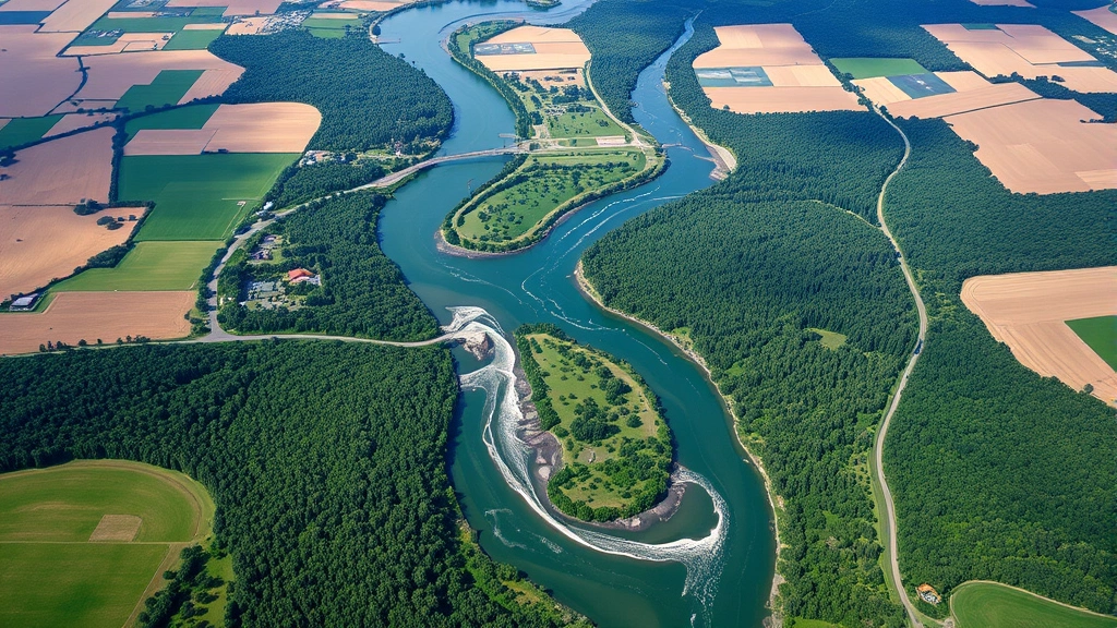
Fluvial and Alluvial Systems
Fluvial environments encompass all subaerially exposed systems where water flows downslope, including braided rivers, meandering streams, and ephemeral wadi systems. These environments are characterized by unidirectional paleocurrents, varying grain sizes reflecting changing discharge regimes, and distinctive sedimentary structures produced by channel migration and overbank flooding.
Braided river systems develop in high-gradient, high-discharge settings where sediment supply exceeds the stream’s transport capacity. These systems produce thick sequences of cross-bedded sands and gravels with minimal mudstone content. Conversely, meandering rivers in lower-gradient settings create distinctive architectural patterns: point bar deposits with fining-upward sequences, oxbow lake fills, and extensive floodplain mudstones. The ratio of channel to floodplain deposits provides quantitative information about paleodischarge variability and basin subsidence rates.
Alluvial fans represent depositional systems at the interface between highlands and lowlands, where streams exit confined valleys and spread sediment across open plains. These environments display rapid lateral facies changes, reflecting the chaotic nature of debris flows and flash floods. Coarse proximal deposits grade distally into finer-grained, better-sorted sediments. Understanding alluvial architecture is crucial for assessing environmental impacts of development in tectonically active regions and for predicting groundwater flow in arid and semi-arid settings.
Paleosols—ancient weathered surfaces preserved within fluvial sequences—provide invaluable paleoclimate information. Soil horizons with iron oxide accumulations indicate seasonal water table fluctuations; calcium carbonate nodules suggest semi-arid conditions; and clay mineral assemblages reflect temperature and precipitation regimes. Integrating paleosol data with sedimentological observations enables reconstruction of seasonal precipitation patterns and vegetation density in ancient fluvial systems.
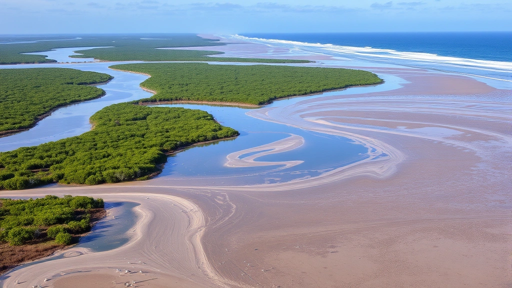
Deltaic and Estuarine Environments
Deltas represent highly dynamic transitional environments where fluvial and marine processes interact to create complex depositional patterns. The relative influence of river discharge, wave action, and tidal currents determines delta morphology and sedimentary architecture. River-dominated deltas like the Mississippi display elongate lobes with prominent levee systems; wave-dominated deltas like the Nile develop arcuate shorelines modified by longshore drift; and tide-dominated deltas such as the Ganges feature elongate tidal channels and extensive sand bars.
Deltaic sequences typically display characteristic vertical facies successions reflecting repeated cycles of progradation and retrogradation. Coarsening-upward successions document seaward delta advance, while fining-upward patterns indicate shoreline transgression and delta abandonment. These sequences are invaluable for understanding human environment interaction in modern deltas, where millions of people depend on deltaic resources while facing existential threats from sea-level rise and subsidence.
Estuaries—semi-enclosed coastal bodies where freshwater and marine waters mix—represent particularly sensitive environments. Salinity gradients create density-driven circulation patterns that influence sediment transport and deposition. Fine-grained suspended sediment often accumulates in estuarine turbidity maximum zones, creating dynamic mudflat environments. Tidal rhythmites—alternating sand and mud laminae deposited during successive tidal cycles—provide quantitative records of paleotidal ranges and can be used to model ancient Earth-Moon orbital configurations.
The economic significance of deltaic environments extends beyond fisheries and agriculture to encompass critical hydrocarbon reservoirs. Many of the world’s major petroleum and natural gas fields occur in deltaic sequences, where organic-rich prodelta mudstones serve as source rocks and delta-front sandstones function as reservoirs. Understanding deltaic sedimentology is therefore essential for sustainable energy policy and economic planning.
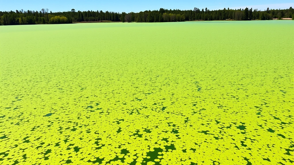
Lacustrine Depositional Systems
Lakes represent sensitive recorders of continental environmental change, responding rapidly to climatic fluctuations, tectonic activity, and human disturbance. Lacustrine sediments preserve high-resolution records of paleoclimate, paleoecology, and paleobiology, making them invaluable for understanding Earth’s climate history.
Lake stratification patterns profoundly influence sedimentary architecture. Meromictic lakes—permanently stratified systems where deep waters remain anoxic—accumulate finely laminated organic-rich sediments with exceptional fossil preservation. These varved sequences, where individual laminae represent annual sedimentation cycles, permit precise chronological correlations and enable reconstruction of paleoclimate variability on decadal timescales. Holomictic lakes, which undergo seasonal overturn, display more massive, bioturbated deposits reflecting aerobic benthic conditions.
Lacustrine carbonate systems develop in closed-basin lakes where evaporation exceeds precipitation and carbonate minerals precipitate directly from supersaturated waters. These systems produce distinctive mineral assemblages—from calcite and aragonite to more exotic phases like trona and halite—that reflect paleosalinity and paleoclimate conditions. Lake level fluctuations, recorded by unconformities and facies changes, constrain paleoprecipitation and paleoevapo-transpiration rates.
Modern lakes face unprecedented pressures from pollution, eutrophication, and climate-driven desiccation. Studying ancient lacustrine systems provides context for understanding ecosystem responses to environmental stress and informs management strategies for threatened contemporary lakes. The economic value of lacustrine resources—including freshwater supplies, fisheries, and tourism—underscores the importance of understanding long-term lake system dynamics.
Marine Sedimentary Environments
Marine environments encompass the vast majority of Earth’s surface and preserve the most complete records of planetary history. From shallow epicontinental seas to abyssal plains, marine sedimentary systems respond to global oceanographic patterns, paleoclimate variations, and biological evolution.
Shallow-marine shelf environments display remarkable environmental diversity. Siliciclastic shelves dominated by sand and gravel grade basinward into mud-dominated slope and basin environments. Wave base—the depth to which surface waves influence seafloor sediments—represents a critical boundary separating high-energy shallow facies from lower-energy deeper-water deposits. Storm-generated tempestites, coarse-grained deposits produced by hurricane-force waves, provide evidence of paleostorm intensity and frequency.
Carbonate platforms develop in warm, oligotrophic marine settings where biological productivity and chemical precipitation dominate over siliciclastic input. These systems display remarkable facies diversity: from high-energy coral reef and coralline algae associations to low-energy lagoonal mudstones and deeper-water pelagic oozes. Carbonate sequences record sea-level changes with exceptional clarity through cycles of exposure and submergence, enabling construction of high-resolution sequence stratigraphic frameworks applicable to hydrocarbon exploration and paleoclimate reconstruction.
Deep-marine environments—slopes, rises, and abyssal plains—accumulate fine-grained sediments interrupted by coarser gravity-flow deposits. Turbidite sequences, generated by submarine earthquakes and slope failures, provide records of paleoseismic activity and paleoslope stability. Contourite deposits, shaped by bottom currents flowing along isobaths, record paleoceanographic patterns and deep-water mass movements. These deep-marine environments host significant metal sulfide deposits—seafloor massive sulfides and sediment-hosted polymetallic deposits—that represent emerging resources for future mineral extraction.
The carbonate compensation depth (CCD) represents a fundamental oceanographic boundary where carbonate dissolution becomes significant. The position of the CCD through time reflects changes in ocean chemistry, paleoproductivity, and paleocirculation patterns. Variations in the CCD have profound implications for understanding carbon cycling and paleoclimate evolution across major geological intervals.
Paleoclimate Reconstruction and Environmental Interpretation
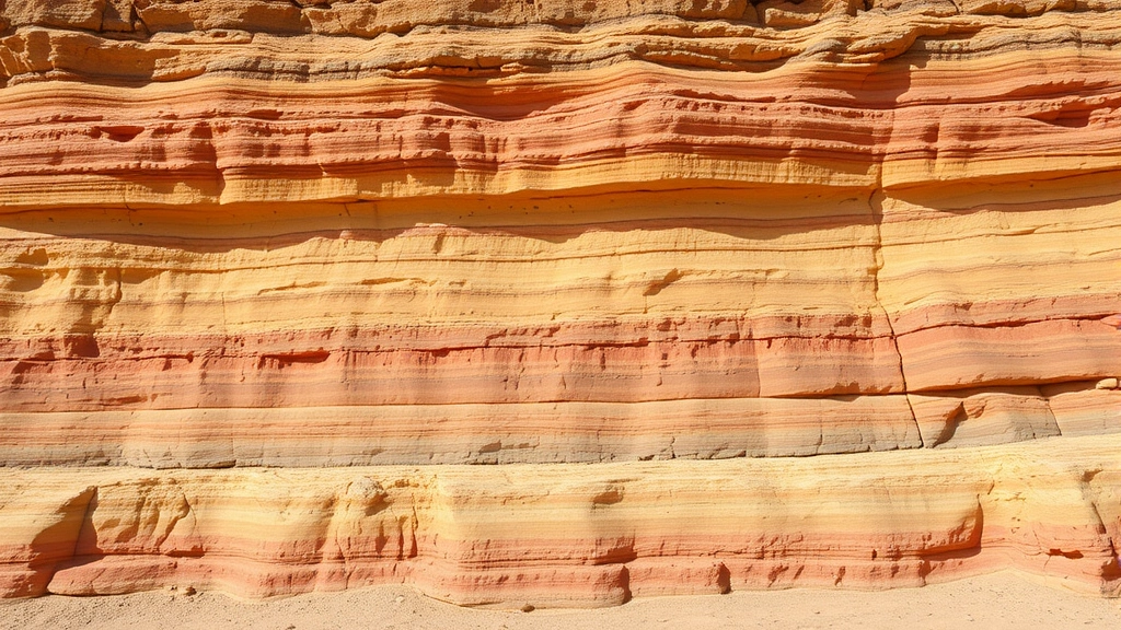
Sedimentary environments encode paleoclimate information through multiple mechanisms. Evaporite deposits—halite, gypsum, and potash—indicate arid climates with high evaporation rates. Glacial deposits (tillites, varves, and ice-rafted debris) document cold climatic intervals and provide constraints on ice sheet extent and dynamics. Laterite and bauxite profiles in paleosols indicate intense tropical weathering under warm, humid conditions.
Oxygen and carbon isotope ratios in marine carbonates reflect paleoseawater chemistry, paleoproductivity, and paleoclimate conditions. Benthic foraminiferal assemblages respond sensitively to water mass properties—temperature, salinity, and oxygen concentration—enabling paleoceanographic reconstruction. Planktonic foraminifera preserve records of surface-water conditions and can be used to quantify paleosea surface temperatures with remarkable precision using trace element and isotopic proxies.
Sediment provenance—the geographic source of detrital minerals—constrains paleodrainage patterns and tectonic activity. Heavy mineral suites, detrital feldspar compositions, and detrital zircon age spectra all provide independent evidence of sediment source terranes. When integrated with paleomagnetic data and paleocurrent measurements, provenance information enables reconstruction of ancient continental configurations and paleotopographic patterns.
The concept of sequence stratigraphy—interpreting sedimentary successions as products of sea-level change—revolutionized sedimentological interpretation. Sequences bounded by unconformities record major sea-level cycles driven by glacioeustasy, tectonics, and changes in mid-ocean ridge spreading rates. By recognizing sequence boundaries and systems tracts, geologists can correlate sedimentary packages across vast distances and develop predictive models of facies distribution.
Economic and Ecological Significance
Sedimentary environments host the majority of Earth’s economically significant natural resources. Petroleum and natural gas accumulate in sedimentary basins, with production rates currently supplying approximately 80% of global energy. Understanding sedimentary depositional systems and diagenetic processes is therefore fundamental to energy security and economic sustainability. As discussed in our renewable energy guide, transitioning from fossil fuels requires comprehensive understanding of sedimentary basins’ historical productivity.
Metallic ore deposits associated with sedimentary systems include banded iron formations (BIFs), which represent the world’s primary iron sources; sediment-hosted stratiform copper deposits; and phosphorite deposits exploited for agricultural fertilizer production. Understanding the environmental conditions that promoted ore precipitation—redox transitions, paleoproductivity maxima, and diagenetic processes—is essential for exploration and sustainable extraction strategies.
Groundwater resources, critical for human survival and agricultural productivity, occur predominantly in sedimentary aquifers. Characterizing aquifer architecture, porosity-permeability relationships, and paleodischarge patterns enables sustainable water resource management. Many regions face groundwater depletion; understanding aquifer recharge rates and long-term hydrological cycles from sedimentary evidence informs water policy decisions affecting millions of people.
The intersection of sedimentary geology with ecological economics becomes apparent when considering ecosystem services provided by sedimentary environments. Floodplain wetlands, deltaic marshes, and estuarine mudflats represent extraordinarily productive ecosystems supporting fisheries, waterfowl populations, and carbon sequestration. These environments face pressures from development, pollution, and climate change. Understanding their depositional dynamics and resilience—informed by sedimentological study—is essential for conservation planning and sustainable ecosystem management.
Carbon sequestration in sedimentary systems represents a critical climate mitigation pathway. Organic-rich sediments in anoxic environments accumulate carbon at rates sufficient to influence atmospheric CO₂ concentrations over geological timescales. Modern initiatives promoting blue carbon sequestration in coastal wetlands and estuaries build directly on sedimentological understanding of how these environments accumulate and preserve organic matter. The sustainable practices increasingly adopted by industries recognize that environmental stewardship requires understanding fundamental geological and ecological processes.
Sedimentary environments also intersect with contemporary environmental discourse through their response to anthropogenic disturbance. Modern sedimentary systems—rivers, deltas, and coastal zones—are being fundamentally altered by dams, coastal development, and land-use change. Studying historical sedimentary patterns provides baseline conditions against which to measure Anthropocene impacts and informs restoration strategies aimed at recovering ecosystem functions.
The World Bank and international development institutions increasingly recognize that sustainable development requires integration of geological knowledge with economic planning. Sedimentary basin analysis informs infrastructure siting, resource extraction policies, and disaster risk reduction strategies. Investment in geological science—particularly sedimentology—provides returns through improved resource management, hazard mitigation, and ecosystem service preservation.
FAQ
What defines a sedimentary environment?
A sedimentary environment encompasses the specific physical, chemical, and biological conditions under which sediments are deposited. These include factors such as water depth, temperature, salinity, pH, oxygen availability, energy regime, and sediment supply. Each unique combination of environmental factors produces distinctive sedimentary deposits with characteristic grain size, mineralogy, sedimentary structures, and fossil content.
How do geologists distinguish between different sedimentary environments?
Geologists employ multiple diagnostic criteria including sedimentary structures (cross-bedding, lamination, grading patterns), grain size distributions, paleocurrent directions, mineral composition, trace element geochemistry, paleontological assemblages, and isotopic signatures. Integration of these multiple lines of evidence permits confident environmental interpretation with quantifiable uncertainty.
What is the economic importance of sedimentary environments?
Sedimentary basins host approximately 90% of global petroleum and natural gas reserves, major metallic ore deposits, phosphate resources, and vast groundwater aquifers. Understanding sedimentary depositional systems is therefore fundamental to energy security, mineral resources, and freshwater availability—critical components of economic sustainability.
How do sedimentary environments record paleoclimate information?
Sedimentary deposits encode paleoclimate through multiple mechanisms: evaporite mineral assemblages indicate aridity; glacial deposits document cold intervals; paleosol characteristics reflect precipitation and temperature regimes; isotopic signatures in carbonates constrain paleoseawater conditions; and fossil assemblages respond to climatic variables. Integration of these multiple proxies enables quantitative paleoclimate reconstruction.
Why are modern sedimentary environments threatened?
Contemporary sedimentary environments face pressures from dam construction (altering fluvial systems), coastal development (destroying deltaic and estuarine habitats), pollution (eutrophication and chemical contamination), and climate change (sea-level rise, altered precipitation patterns). Understanding these systems’ historical dynamics informs conservation and restoration strategies.
How does sedimentary geology relate to carbon sequestration?
Organic-rich sediments in anoxic environments accumulate carbon at rates influencing atmospheric CO₂ over geological timescales. Modern blue carbon initiatives in coastal wetlands and estuaries directly apply sedimentological principles to enhance carbon sequestration. Understanding historical sedimentary patterns informs strategies for maximizing carbon burial in contemporary systems.
What is sequence stratigraphy?
Sequence stratigraphy interprets sedimentary successions as products of sea-level change. Sequences bounded by unconformities record major sea-level cycles driven by glacioeustasy, tectonics, and mid-ocean ridge spreading rate variations. This framework enables correlation of sedimentary packages across vast distances and development of predictive models for facies distribution.